
Updated at 8:02 p.m. PDT Sept. 7, 2022
The Radford Fire at Big Bear Lake in Southern California was mapped at 1,052 acres at about 12:30 p.m.
The video below shows a hotshot crew conducting a burning operation on the fire.
The next video was shot by the FIRIS mapping aircraft at 11:17 a.m. Wednesday. When it switches from visual to infrared, the white areas represent heat. If you look carefully you may see some circular black areas along a ski run where sprinklers have been activated.
OES Intel 24, Sept 7th on the #RadfordFire, BDF. Fire is mapped at 1,040 acres at 11:17 hours. pic.twitter.com/3kiTtJh1bm
— FIRIS (@FIRIS) September 7, 2022
Updated 7:15 a.m. PDT Sept. 7, 2022
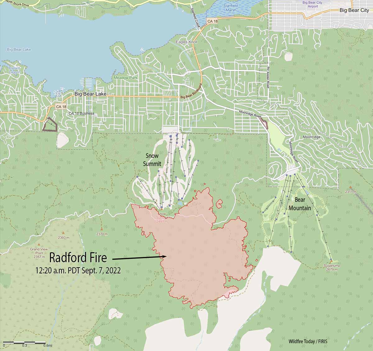
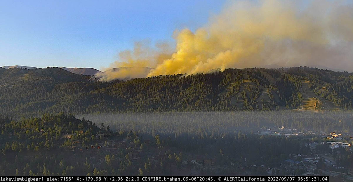
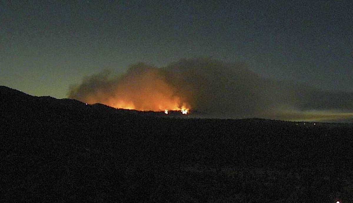
As the sun came up Wednesday morning cameras showed the Radford Fire near Big Bear Lake in Southern California was very active. A 12:20 a.m. mapping flight found that it had grown to about 980 acres and had spread 0.4 mile north of Skyline Drive/FR 2N10. At that time it was between the two ski areas, Snow Summit and Bear Mountain, but was still high on the slopes, about 0.8 mile from Switzerland Drive.
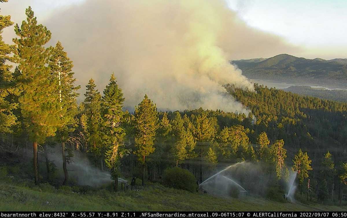
The ski areas are using the water systems for the snow making machines to wet down the vegetation on the ski runs.
Evacuations are in effect. The San Bernardino County Sheriff’s Office has the current details.
#RadfordFire Evacuation Warnings⚠️:
The area of Club View east to Angles Camp Rd & Vine Ave south to Lassen Dr.Summit Blvd east to McAllister Rd, east of Hwy 18 & Fox Farm Rd south to Evergreen Rd.
For an interactive map of the evacuation warnings ➡️ https://t.co/GcKkmnhbr4 pic.twitter.com/cIsg0REKKO
— San Bernardino County Sheriff (@sbcountysheriff) September 7, 2022
Updated 10:34 p.m. PDT September 6, 2022
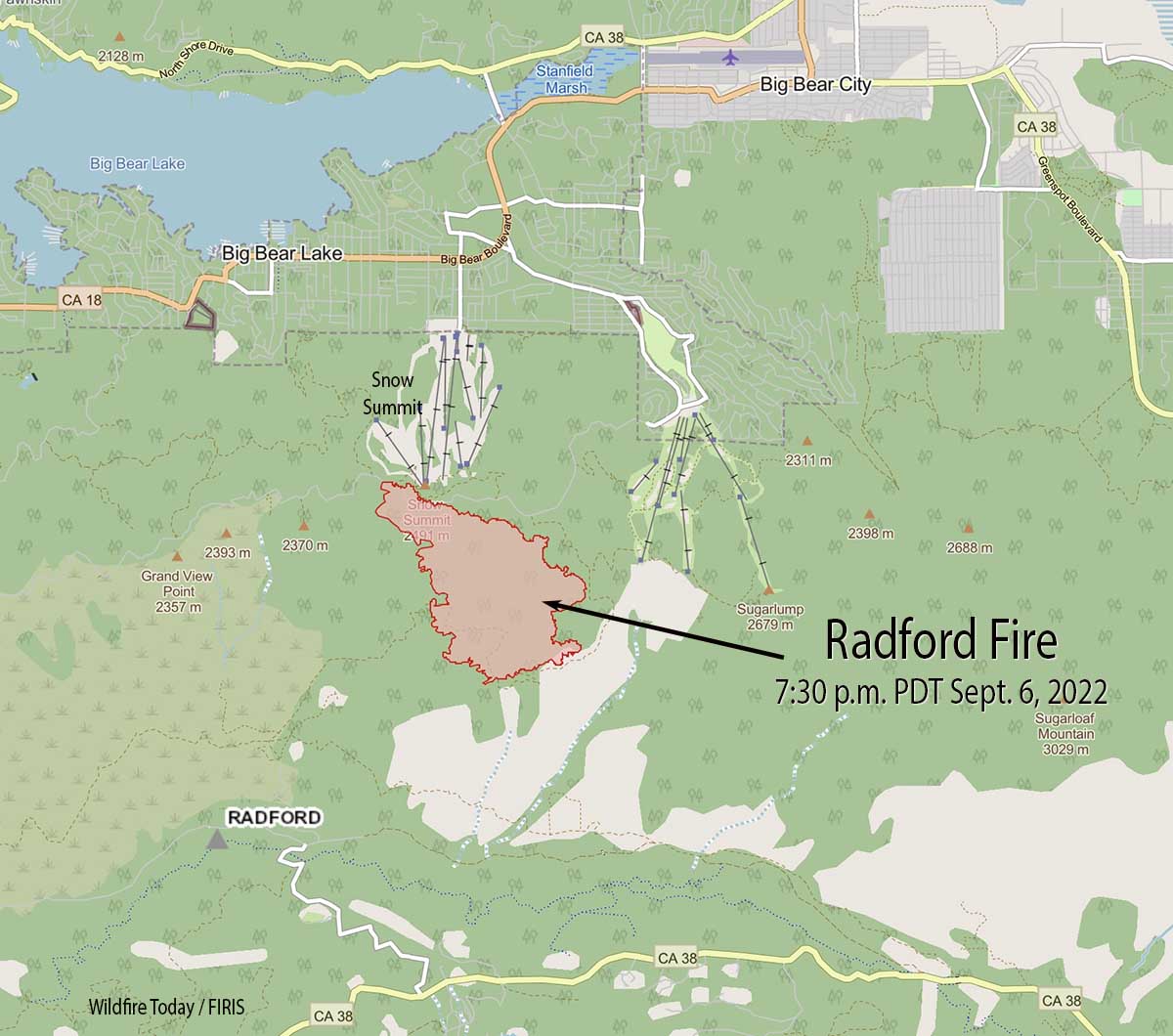
The Radford Fire south of Big Bear Lake has spread to and crossed over the NF-2N10 road above the Snow Summit ski area. The US Forest Service says the fire has grown to 917 acres.
San Bernardino County has posted a map showing the areas under evacuation orders. (click the arrow at the bottom-left corner of their map to see the legend which interprets the colors indicating the status of evacuation)
California Interagency Incident Management Team 11 with Incident Commander Fogle will assume command September 7 at 7 a.m.
12:16 p.m. PDT September 6, 2022
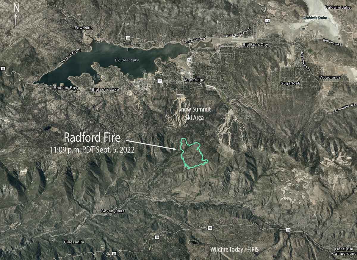
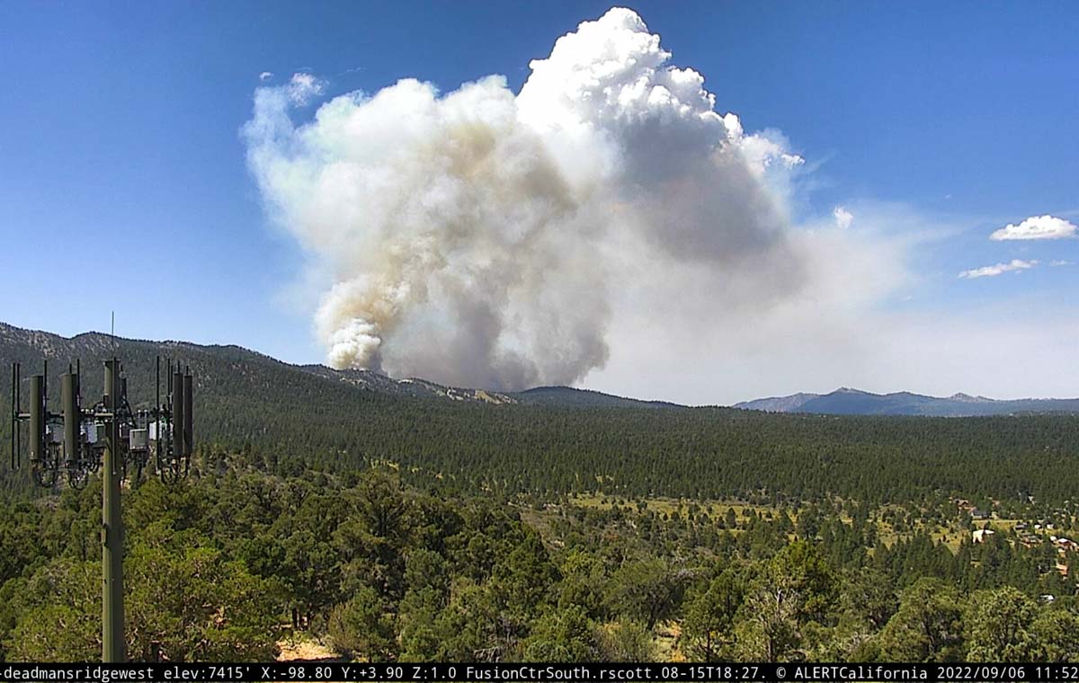
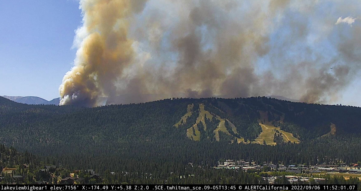
The Radford Fire has burned hundreds of acres in Southern California just south of the Snow Summit Ski area which is south of Big Bear Lake (see map above). It started north of Highway 38 in the Barton Flats Area. Tuesday morning the fire was burning on the south-facing slope below Snow Summit. At about 11 a.m. the lens on the Snow Summit South camera was suddenly coated with red fire retardant. There is infrastructure on the mountain that will be important for firefighters to protect.
When the FIRIS mapping aircraft was over the fire at 11 p.m. Monday 332 acres had burned and spot fires were growing out ahead of the main fire. At about 11 a.m. Tuesday the San Bernardino National Forest reported it had grown to 450 acres. Looking at the views from several fire cameras at 11:30 a.m. today the fire was very active and appears to be spreading vigorously.
The Radford Fire was reported at 1:30 p.m. on September 5th by a US Forest Service Helicopter while conducting lightning reconnaissance.
The San Bernardino County Sheriff’s Department is posting evacuation information on their Facebook page. To receive evacuation notices on your cell phone, go to the San Bernardino County Fire Telephone Notification System.
A Type 2 helicopter dropped water on the fire overnight.
The camera lens below was coated with retardant from an aircraft late Tuesday morning.
The video below was recorded by the FIRIS mapping aircraft at about 11:30 p.m. Monday. The white areas represent heat.
OES Intel 12, Sept 5th on the #RadfordFire, BDF. Fire is mapped at 332 acres at 23:27 hours. pic.twitter.com/gy4kejGF6g
— FIRIS (@FIRIS) September 6, 2022
The article was edited Sept. 7 to show that a single helicopter dropped water on the fire Monday night, not retardant. Helicopters dropped retardant that night at the nearby Fairview fire.

Did Camp Radford burn? The actual camp
Should sugarloaf residences be evacuating?
What does it mean when the article says “The Radford Fire was reported at 1:30 p.m. on September 5th by a US Forest Service Helicopter while conducting lightning reconnaissance.” What is a lightning reconnaissance? They need to explain.
It means that lightning was observed in the area so the area was reconnoitered to search for fires that may have been ignited by the lightning. This is a standard procedure.
Slight typo there sir. There were no helicopters dropping retardant on that fire on Monday night. Just one Type 2 helicopter contracted to USFS, operated by Helicopter Express, dropping water on it, and working alone all night long.
Fixed it.
For typos or errors, please contact us here.
Big Bear Lake and City are to the north of the Radford Fire path. Hundreds of structures maybe in the fire path.
Is there any idea now, on Tuesday, which way this fire might go? I worked at Camp Osito Rancho many years ago. It is west of that ski area. At least the summer campers are gone. This is the second Girl Scout Camp that I have worried quite a lot about this summer, The first was Pine Creek Ranch on the Salmon River. Way back, as a kid, my first summer at GS Camp was in the Santa Cruz Mountains, 4 miles inland from the Pacific. Our unit was moved as the area we were meant to camp in had been burned the year before and the campers had been evacuated. That was in 1963. And was it only 2 (3?) years ago that much of Big Basin State Park, the oldest California State Park, burned. I camped there many, many times with large gatherings of Santa Clara County Girl Scouts throughout the 60s. For some reason I live in Florida now, but here it can rain 5″ in an hour. Not such a bad thing. I do hate to read about so much of my childhood going up in smoke.